

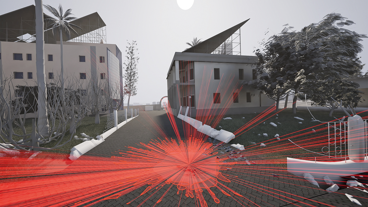
On 17 October 2023, an explosion took place in the courtyard of al-Ahli Hospital in Gaza City. Forensic Architecture created a digital reconstruction of the blast by tracing lines from the crater to the locations of shrapnel markings on buildings around the courtyard in order to better understand how the incident unfolded. From When it Stopped Being a War: The Situated Testimony of Dr Ghassan Abu-Sittah, Forensic Architecture, 2024.
What would it mean to see the world – long-term and predominantly – from the perspective not of the victors but the survivors? Forensic Architecture and Giles Price consider their efforts towards a psychological transformation of eyesight and images of war
A rocket strikes a hospital. Hundreds die. A spokesperson for the Israeli military appears on the mainstream media of two further states, the BBC in the UK and CNN in the US, holding up an image of a flash in the sky, a still pulled from a video. He attributes this bright light, this explosion, to a misfiring rocket launched by Palestinian Islamic Jihad. But really, he says, we do not need to go extensively into these details.
Going into detail is the hallmark of the image-based evidentiary practice of Forensic Architecture (FA), the research centre based at Goldsmiths, University of London and with affiliates in cities around the world. Its approach to working with the photographic image – in tandem with technologies such as mapping, spatial analysis and photogrammetry – has made manifest aspects of documentary photography that might seem to unburden it of its troubled status as proof; its performativity, its constructedness, its inherent uncertainty. Yet instead, FA’s practice offers the documentary image as a potent vector for uncovering facts, not as representation but by offering an explanation.
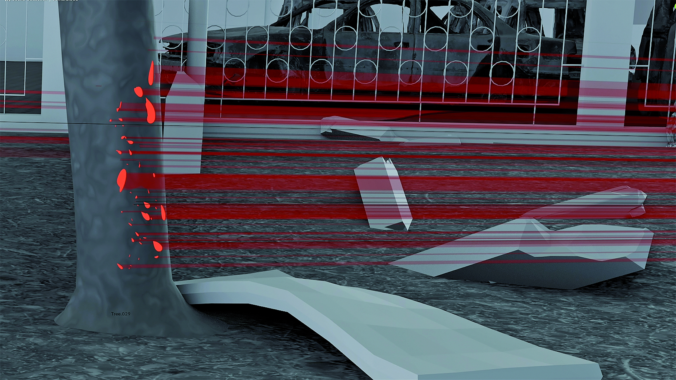
“I wanted to mirror the surveilling and targeting point of view, but with the hi-res and clarity to see the destruction caused by it. At ground level, the rubble was comprised of homes and schools” – Giles Price
In relation to the pulled image, the Israeli military spokesman invoked public trust in seeing and believing, as he superimposed his own narrative on the still. But FA geolocated, stabilised and positioned the original footage, alongside another video of the same event, within their existing 3D model of Gaza, to show the explosion pictured is in fact an Israeli interceptor. Everything turns on the detail.
Detailism, as Piyel Haldar writes, is a technique of visual dissociation, which entails a stepping back from what can clearly be seen, to pay attention to something considered otherwise irrelevant. It was used by art historian Giovanni Morelli as a method to identify fake paintings by the tiniest, least significant feature, and acknowledged by Freud for its similarity to the process of psychoanalysis. While this method can be applied to the individual photograph – it is, after all, closely affiliated to Walter Benjamin’s concept of the optical unconscious – its potency is amplified when many photographs of an event or a location can be found, analysed and measured.
Since the advent of Google Earth, the photograph’s relationship to mapping has taken centre stage; in fact, the former has replaced the latter. Maps are now photographs, though their histories have always been entwined. The long-standing art of cartography was wholly reshaped by the photographic, which enabled new ways to create spatial and geographic representations. Following the vision of Nadar, who pictured Paris in 1858 from a hot air balloon tethered to the Arc de Triomphe, American photographer JW Black flew a balloon above Boston Common two years later, to picture his city in Boston, as the Eagle and the Wild Goose See it.
Photographic technologies combined with map-making to extend ways of seeing the world, and were quickly utilised to military ends, creating a form of visual power and cultural dominance. The union of airplanes and photography – “these two globalising mediums” to quote Allan Sekula – helped rationalise the practice of warfare; an ongoing process. In his 1936 essay From Pigment to Light, photographer László Moholy-Nagy referred presciently to the meeting of photography and cartography as an “advance in technique [that] almost amounts to a psychological transformation of our eyesight”.
This transformation quite literally brought another dimension to the act of seeing, especially when used in conjunction with photogrammetry, used as early as 1851 for topographic surveying by French military officer Aimé Laussedat. The practice evolved due to the efforts of Albrecht Meydenbauer, a government surveyor, who created the first 360-degree photographic record of Berlin in 1868. Compared to an earlier, pin-sharp camera lucida-created painting of Berlin, it was a visual failure; blurry, imperfect. But its aim, resonant with FA founder Eyal Weizman’s 150 years later, was to offer more than a visual record; it evidenced visual order.
Naming this order, Weizman says, “The ‘politics of verticality’ entails the re-visioning of existing cartographic techniques. It requires an MC Escher-like representation of space, a territorial hologram in which political acts of manipulation and multiplication of the territory transform a two-dimensional surface into a three-dimensional volume.”
It is this understanding that has shaped Weizman’s decades-long investigation into the violence enacted upon Palestinians by the State of Israel, the land of his birth. He has defined the multiple spatial practices designed to control every facet of life in the Occupied Territories, including militarising the airspace, politicising access to water, and – via archaeological excavation – the narrative of the ancient past. At the same time, the complex patchwork of roads, bridges, tunnels, checkpoints and borders create, from its struggle to ‘separate the inseparable’, a hollow land, a phrase that would become the title of one of his, and FA’s, foundational texts.
It was via mapping techniques that Weizman was able to demonstrate this thesis, and through the continued use of mapping, geolocation and photogrammetry, as well as via open-source data, images and 3D modelling software, that the practice of counter-forensics was established. Its philosophical underpinning was born of Edward Said’s insistence on counter-cartography as an act of resistance, and his call for new images and imaginings in the “struggle over geography”.
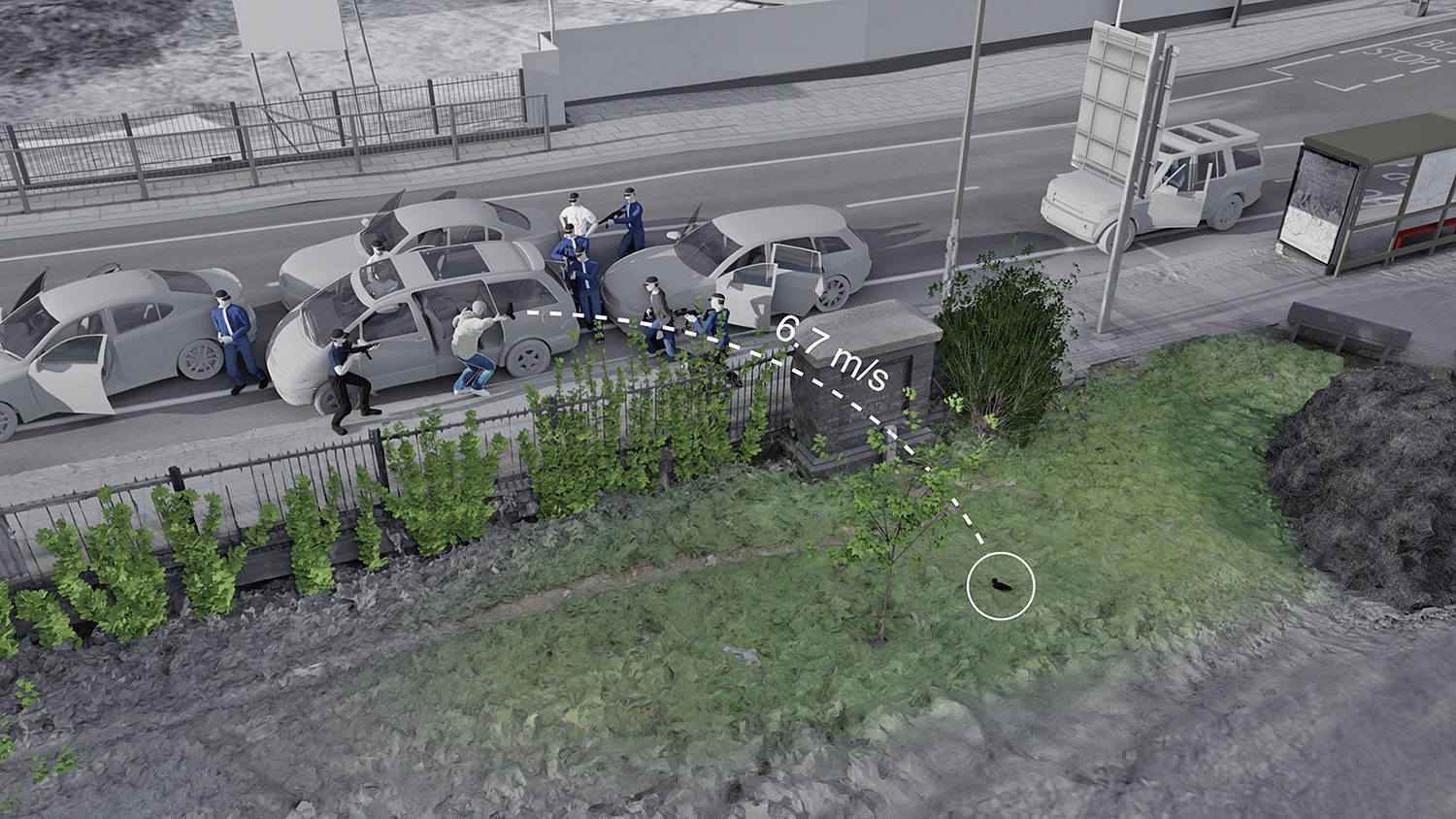
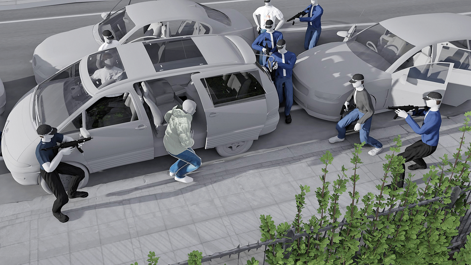
The nature of counter-forensics makes it a useful vehicle to investigate state violence, both internationally and in the UK. The FA investigation into the killing of Mark Duggan by an anonymised Metropolitan Police officer in north London in 2011 served as evidence to support his family’s claim for damages against the police force, following an earlier inquest’s verdict of ‘lawful killing’. FA used contemporary photographs made public by the inquest, as well as site surveys, to create a 3D model, using photogrammetry techniques. Statements by police officers present at the scene created the next evidentiary layer, forming the foundation of a complex display highlighting the contradictions between their accounts. FA’s use of testimony to expand the visual has become cardinal to its methodology.
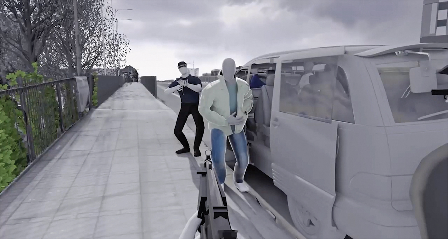
In relation to the Duggan case, as an evidentiary work, the model, or ‘assemblage’, was able to show the precise position of Duggan’s and the officers’ bodies, and locations, at the time the shots were fired. The analysis focused on the alleged throwing of the gun said to be in Duggan’s possession, which was found almost seven metres away from where he was shot. The counter-investigation reveals various gaps in video evidence, noting that of the seven video files that comprised ‘Witness B footage’, only six were referred to by one of the specialist image analysts employed by the inquest. A further gap in the footage occurred at a moment that was heavily scrutinised by the court, yet was left unmentioned.
This gap reverberates with the evidentiary echo of the withheld Frame 313 from Abraham Zapruder’s home-movie footage of President JF Kennedy’s assassination in 1963, which he sold to Life magazine, requesting that one exceptionally gory frame never be shown. Film-maker Errol Morris calls this frame ‘the forensic heart’ of the 26-second film. Life complied with Zapruder’s wish, and the frame that might contain the crucial documentary evidence to determine the position of the assassin was not seen for 12 years.
Such omissions, intended or otherwise, form another important aspect of FA’s modus operandi. Uncertainty can be the impetus for investigation and its character. The meticulous written investigation reports produced by FA often acknowledge the presence of uncertainty, though aesthetically, its visual outcomes do not dwell in this register. There is a tension between the precise, authoritative, sonorous voices of the narrators of its completed presentations coupled with the clinically clear imagery it employs, and the concept of accepting the shadow of a doubt.
The question of uncertainty floats across the public spaces in which the work of FA appears: museums, art galleries, courts of law. Each space affords different audience consideration of the material on display. The Killing of Mark Duggan investigation became a featured display within the wider exhibition War Inna Babylon: The Community’s Struggle for Truth and Rights at the ICA in London in 2021, where the vibrant history of Black activist organisations took centre stage, as well as testimonies from families whose loved ones had died in police custody. The inherent contradictions between varied forms of bearing witness, from the juridical to the artistic, were given breathing space in the public forum. The exhibition exposed the porous nature of the border between fact and proof, showing the much-needed potential for an expanded legal imagination. Though the legal appeal predating FA’s research was unsuccessful, every element of the ICA show felt like a step towards justice.
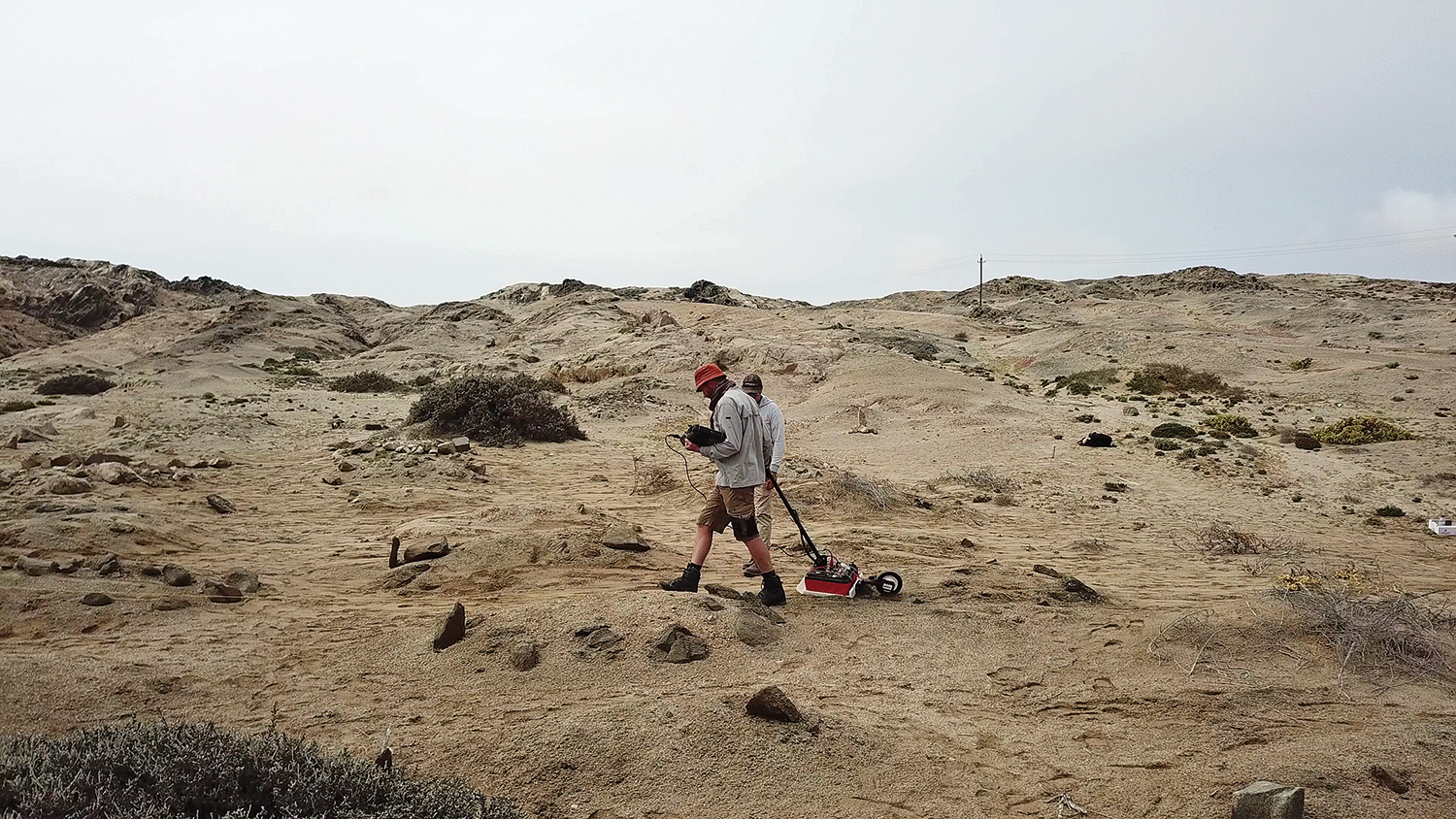
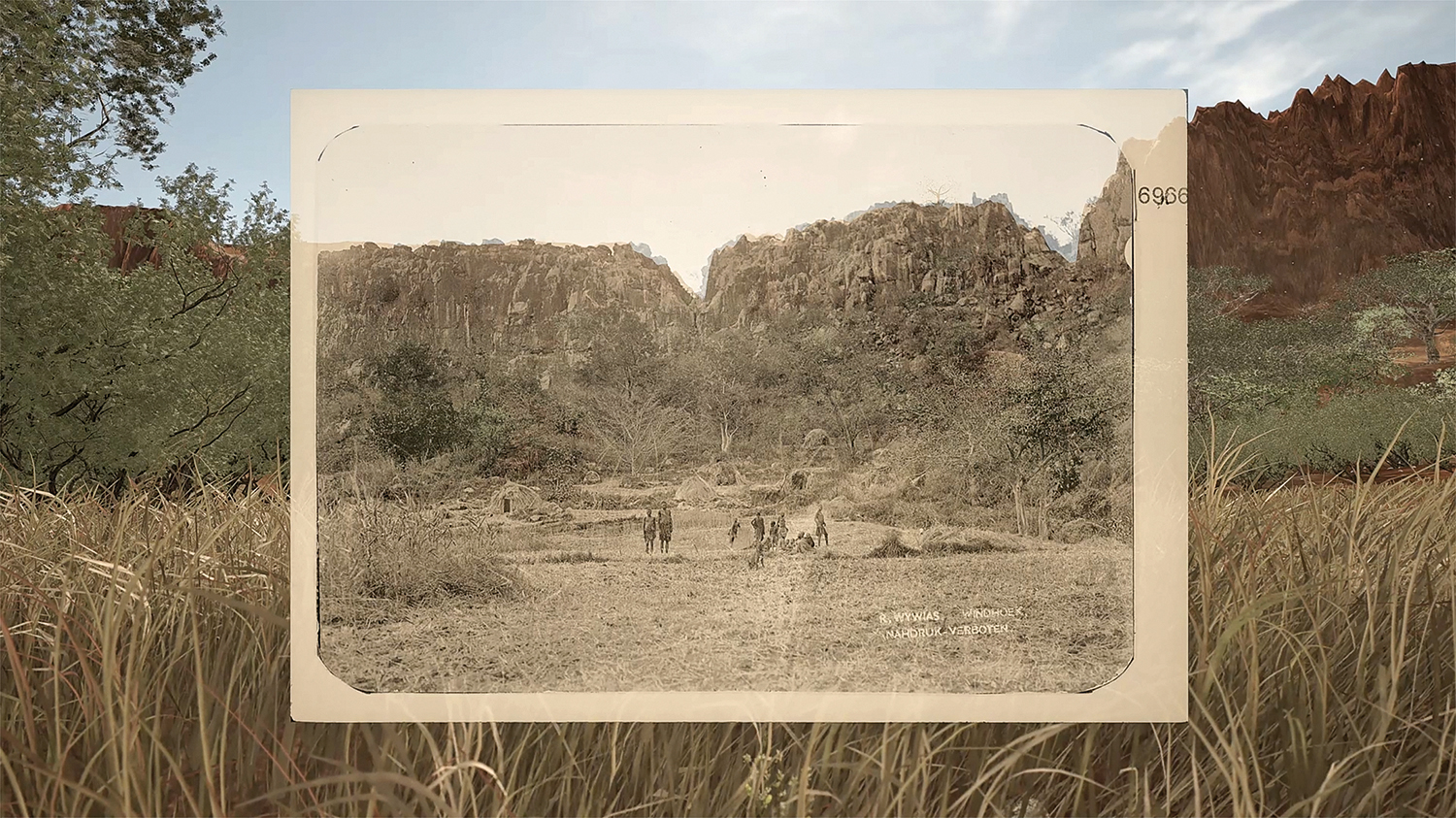
Recent FA investigations show the potential for a reading of images that shifts from the archival and art historical to the juridical, in its work on the German colonial genocide in Namibia. Working with both historical photographs and maps from this period, researcher-in-charge Agata Nguyen Chuong describes how the violence of the colonial archive was revealed, in a foreshadowing of the regime’s genocidal ways of seeing. “Landscape photography, framing a Lebensraum for German settlers – and often disseminated as postcards – or cartographic annotations on maps, betrayed genocidal intentions of erasure and land dispossession before they materialised on the ground. In this context, the notion of ‘photographic restitution’ – returning images to their environmental and cultural contexts – became central to our method.”
Comparing contemporary and archival images enabled a close reading to understand, for example, a transformation in grass growth that, combined with other details of land degradation and dispossession, evidences a crime we might soon be able to name as ecocide; so often genocide’s bedfellow. What happens to the land happens to people too. An 1897 map shows the extent of settler farms and how a proposal to establish native reserves would contain Indigenous people and restrict their movement. The Namibian people, via German, then British, then South African regimes, suffer from the far-reaching consequences of such division today.
Reading the contours of historical maps in conjunction with testimony from the elders of Otjimbingwe demonstrates how German colonial expansion was driven by the availability of water and grazing lands. Photographs from 1897, when combined with inherited testimony, enabled modelling of vegetation and trees, placing them back into the once richly biodiverse and fertile landscape. What had been wilfully misunderstood as a barren landscape, or a void – that erroneous lynchpin of colonial logic – is proven to be full of life.
Says Nguyen Chuong: “In this investigation, inherited testimonies were vital – as an act of resistance against the completely erased settlement and a way of life. Through the research, oral histories enabled the images to yield truths that colonial depictions had tried to obscure. Inherited testimonies add resolution to the subtle visual cues in the photographs, transforming our reconstructed landscape into a lived environment. Through these methods we attempted to re-situate this fraught material within the ontologies colonial violence had sought to erase.”
FA’s research into Israel’s actions towards the Palestinian people charts an inescapably similar trajectory: strategic destruction of agricultural crops, the poisoning of wells and the destruction of olive trees – some of which are older than the State of Israel and are a central symbol of Palestinian identity, as well a source of income. Making these invisible processes of control and destruction visible evidences specific practices and policies which are replicated across centuries and geographies to the same end.
Rather than as a caption, or an accompaniment to a portrait – important though these modes surely are – testimony is used here to expand the possibility of the image. This has consequences for the humanist model of the ‘concerned’ documentarian, whose empathetic imagery might lose its charge or at least its efficacy. The sharing of lived experience repositions its narrator from a potentially vulnerable role, as someone to whom something (terrible) happened, into the source of vital knowledge, thus creating an expanded way of seeing. Inherited testimony, a precise remembering of transgenerational knowledge in indigenous worldviews, also offers a challenge to the lesser status of testimony in law.
Another intriguing aspect, especially when taken into consideration with the mnemonic qualities of photographs, is how these visual assemblages are created from memory, often traumatised memory. It is important to note that the process for engaging with these memories has been developed with Goldsmiths’ Forensic Psychology department, to avoid potential retraumatisation. Yet, at the same time, the unspoken acknowledgement of seeing the world through the eyes of those traumatised by colonial or state violence is in equal parts tender, shocking and profound. What would it mean to see the world, long-term and predominantly, from the perspective not of the victors but the survivors?
What might be drawn from this kind of work is a significant shift in the role of the contemporary documentary photographer in relation to the concept of visual evidence. But what is the role of the individual practitioner in relation to this distinctively collective way of working? Further, what is the role of the conflict photographer in particular, already significantly changed in relation to technologies of war, since the ‘shock and awe’ tactics employed by the US in Iraq and the rise of asymmetric warfare.
At this moment such a role in Gaza is non-existent, as international press are banned from entering the territory in which atrocities are taking place, and nearly 200 local – mostly Palestinian – journalists have been killed by the Israeli military since October 2023. It is frequently medics and citizens, frighteningly close to the bloodshed, who are today’s documentarians.
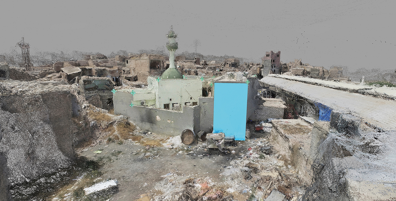
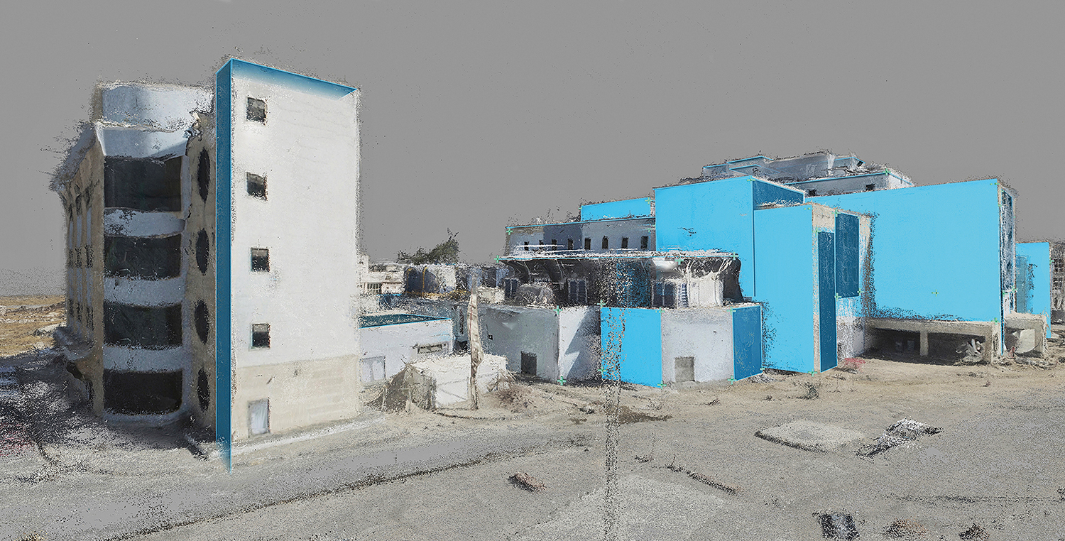
Increasingly, conflict-related or counter-colonial projects take place necessarily at a distance, and there is a trend towards employing techniques of mapping and use of open-source, as in the work of Bouchra Khalili or investigative collective RAKE. The work of former Royal Marine Giles Price on the reconstruction of Iraqi city Mosul offers a unique perspective shaped by a first-hand understanding of military seeing and a collaboration.
Price was just 17 years old when he worked on operations in northern Iraq in 1991 to halt the advance of the Iraqi army towards the displaced Kurdish population, who US special forces and UK allies were charged with protecting. Exposure to the same chemical weapons deployed by Saddam Hussein against the Kurds resulted in medical discharge for Price, followed by 14 years of major surgeries, with life-altering consequences. As he pursued his pre-military passion for photography, he mostly avoided conflict work, but in 2017 he was commissioned by The New York Times Magazine to document wrongly-targeted coalition strikes in Mosul, which caused a high number of civilian deaths. Moreover, this military action was being misreported in the US and UK press as the most accurate air campaign in history.
Price knew he required the aerial view. “I wanted to mirror the surveilling and targeting point of view, but with the hi-res and clarity to see the destruction caused by it,” he says. “At ground level, the rubble was comprised of homes and schools.” In this first visit, unable to take a drone into Iraq, he achieved his desired vision by mounting his camera on a 12-metre telescope carbon fibre pole, triggered with a wi-fi remote.
Drone use has become somewhat ubiquitous within popular as well as critical photography, in tandem with this kit’s commercial availability. Price has been using Chinese-made consumer drones since 2014, the same drones used in Donbas, Ukraine, after the Russian invasion. “Isis in 2016 were the first to weaponise their use by easily modifying them to drop bombs, which led to their widespread use in the battle of Mosul,” he notes. Price was able to rent one from an Iraqi army officer, but geolocation blocks were in place. Unable to use the standard flying software, he found a workaround in photogrammetry apps, sowing the seeds of a new way of working as he did so. Offered “multiple data assets in 2D, 3D and moving image” for the NYT commission, a photogrammetry animation featured in its online edition.
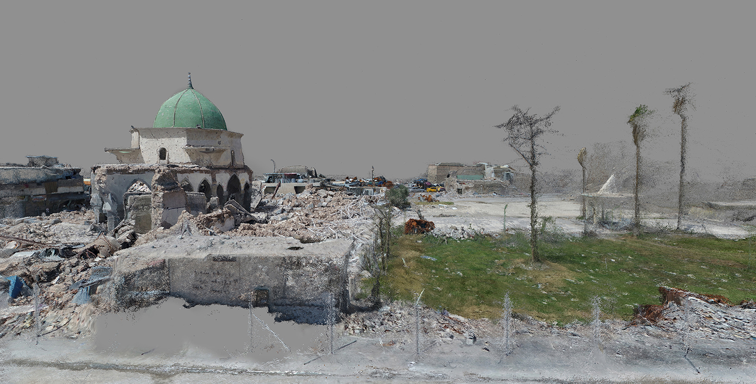
Price’s work Phantom Pro grew out of a relationship with an Iraqi videographer, Ayar Rasool, who purchased the drone from the army officer. Over WhatsApp, Price trained Rasool to fly photogrammetry apps. His ongoing collaboration with Rasool is documented via their messaging, sharing an easy intimacy across time and space; another mode of bringing the human voice into the creation of images. Particularly interested in the al-Nuri mosque, Price paid Rasool to make a photogrammetry set of the iconic symbol of Isis dominance. The ancient mosque was the site of the infamous 2014 sermon in which Isis leader Abu Bakr al-Baghdadi claimed a new caliphate, and which his militant group blew up in a final act of vengeance before Mosul fell.
Fast forward to an image of that site now. Aesthetically, it hovers somewhere between a graphic and a painting. The matt grey sky conceals any trace of the threat it once held. A further block of featureless matt grey obscures a patch of foreground. Could it screen a body, killed in the blast? In fact there were no direct fatalities as a result of the Isis bombing, but thousands were killed in the battle for Mosul. Amnesty International reported as many as 10,000 civilians were killed in the nine months of the battle, calling for the Iraqi state and US coalition forces to accept responsibility for the deaths. The mosque’s turquoise dome in this image is its defining feature, yet the surrounding rubble has subsumed al-Hadba, its singular, leaning minaret, built in 1172. Attendant trees take on a spectral quality, appearing to have been burnt alive, as though signifiers of ecocide.
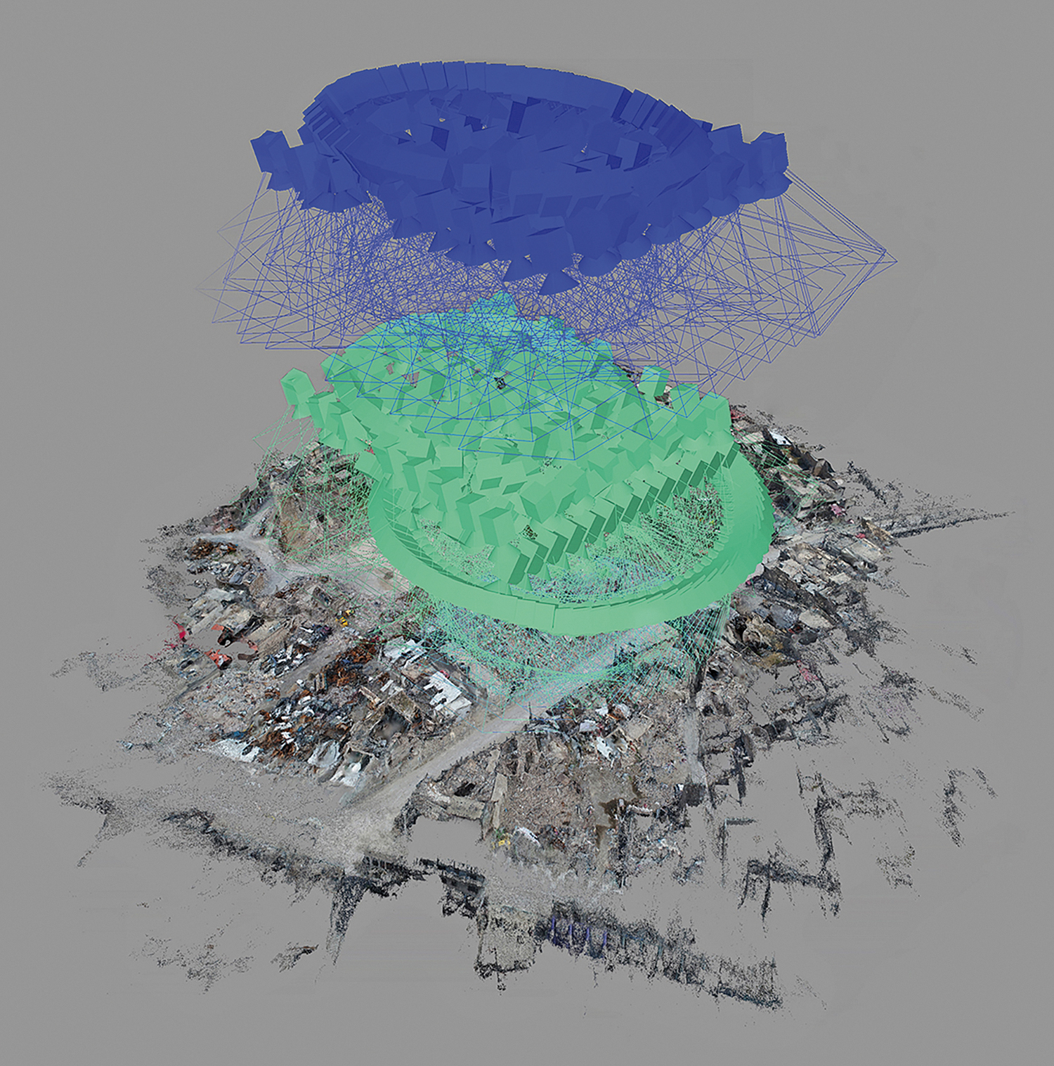
Other images in the series make manifest the data points within the photogrammetry software, tiny green crosses clustering like so many targets. This mode of contemporary conflict reporting transfers the power of the military plane of seeing to the individual; what can be seen from the sky is seen on the screen, allowing for different interpretations. The image Azersjkhan Neighbourhood uses what Price calls “the expressive tactic of leaving visible the computational processes and photogrammetry software artefacts” within the image. On first sight, this image evokes spacecraft, hovering above the territory.
It is hard to escape the thought that this is the position of invading armies of the future, surveilling for an occupation yet to come; continuing the rise and fall of empires across the centuries, phantoms of the air that cannot be put to rest. These unearthly structures cast their nets across the plane of military seeing; the politics of verticality captured in Technicolor. By inserting these constructed images back into Google Earth, Price reshapes both corporate and state narratives in terms of what is available to be seen.
Price is passionate about how photogrammetry techniques move beyond 2D to bring a credibility that can shatter deliberate disinformation. While, as Harun Farocki noted in his prophetic 1989 film Images of the World and the Inscription of War, we have more pictures than the eyes of the world are capable of evaluating, Price’s contribution allows for a changed role for the observer. A sense of agency is reinscribed into the individual, a kind of respite from the proliferation of images bleeding out into the world.
These differing but related visual and spatial practices bring a vital criticality to our regimes of seeing. In uniting place, sight and voice, the previously disembodied art of mapping, which has so often served to divide and conquer, is imbued with a new potency. These imperfect assemblages reveal a shift from a photography that describes, or represents, to one that helps to explain, clarify, imagine and, sometimes, to prove. The interpretive role remains crucial. Ancient or modern, mapping techniques can also simply help us to know that there is a way home.
Giles Price’s series Phantom Pro is on show as part of the Impact Kyiv: Forum of War and Conflict Photography at The Ukrainian House of Photography from 15–18 October 2026.